
Rockies Summer of 2002
AROUND THE MISTY RANGE
DAY 12 - AROUND THE MISTY RANGE
This is the ride that had been talked up. The famed 4 passes. The 27 % average grade of Rickerts Pass. The views. It was all that and so much more.
It starts with a drive south of Canmore down the Smith Dorrien road - past the Spray Lakes. This drive is beautiful in and of itself and in winter the road is ploughed and accessible for backcountry skiing. The best part of it is that - since it is in a park - no snow mobiles are allowed so the snow stays relatively untracked. I spent a good part of the time drooling at the variety of skiing terrain which Greg kindly pointed out.
The ride itself goes around the Misty Range cutting over Elbow Pass just to the south of the Opal Range; Sheep Pass and then Rickerts Pass. The Misty Range itself is short; only 17 km but it is a stunning range of mountains.
We were all bagged so were only too quick to accept Kevin's offer of doing just half the ride and shuttling drivers back to the northern trailhead starting point. Geez - we would have to cut out one pass and 250m of climbing over 22.5 km! Kevin was to climb UP the southern end of the trail up Mist Creek and to the top of Rickerts to meet us there.
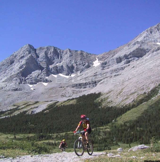
Unfortunately, it would mean that we would start the first climb up to Elbow Pass without warmup. Here is Brian leading Bob and Laurie up the climb to Elbow Lake starting at 2000m and ending at about 2090m in the first 1 km on trail..

Fortunately the views from Elbow Lake are gorgeous. Roger and Brad are dwarfed by Elpoca Mountain in the background at an elevation of 3029 m or about a vertical km above the lake.

Mt Rae frames the south east view of the lake at 3218m

Here is the group with the ridgeline and north shoulder of Mt Rae in the background

Roger and Mt Elpoca seem to have this synergy thing. Here he is navigating a stream crossing with that same 1 km vertical slab of rock balefully looking down at him.

Continuing east past Elbow Pass, the trail levels out. This view shows the mountains of the Elk Range to the west looking past the watershed of the Pocaterra Creek past Highway 40.

This nice shot is taken facing south - a little into the sun - and shows the rather dramatic south face of Mt Rae in the right side of the shot with the Rae Glacier cupped in the middle and Mt Arethusa at 2912m on the left. Rob nicely completes the picture.

Roger with Mt Rae as the backdrop a little further down the trail.

The rather distinctive ridge of Mt Rae recedes further into the backdrop as Brian and Hadi try to concentrate on riding and not looking too closely at views.

Taken north from the main trail, this is Tombstone Mountain. I am too close to it to capture the peak at 3,035m or also about 1 vertical km above the valley floor. Sharon appears to be looking at the views and not concentrating on the trail. Concentrate little one!
Here is Bob with Tombstone Mountain as the backdrop concentrating. Go Bob!

Further along and close to the junction of the Elbow Loop; Brad and Rob find a few up sections in this relatively flat part of the ride. The Elbow Pass can be seen in the background.

Laurie smiles because she doesn't know what is going to nail her right between her perky little Georgian eyes. Rae Glacier and Mt Rae form the backdrop.

We reach the Elbow Loop junction where the Misty Range trails and the Elbow Loop converge. At this point one can continue north into the Elbow Loop or east continuing down the Misty Range to Sheep Pass. Tombstone Mountains south peak to the left and Banded Peaks ridgeline to the right dominates this picture. The Little Elbow River forms the valley in the middle.

The group takes in the view and counts bodies. Tombstone Mtn ominously pronounces its epithet in the background.

Continuing past the Elbow Loop junction we descend a gravel wide part of the trail and then ascend a short steep section and cross Sheep Pass where we stop and have lunch. Seb wonders where the Marmite is while Brad steals his peanut butter bagel.

After Sheep Pass there are many creek crossings. Not just one but a lot. Here is Laurie showing why she does not like cold water.

I would like to say that everyone rides like Brian and makes every creek crossing ....

but I would be lying, eh Greg?
 '
'
Hadi seems to want to ride right through Mt Burns at 2936m; he was charging pretty hard today. He must have been pretty happy to get out of Ontario and make it back to the west where he belongs!

With the main trail being so flat, we reach the climb to Rickert's Pass fairly quickly. The group assembles and say mutual goodbyes after the ritual sock-drying session.

Words cannot describe the sheer horror of what is to come next so I will just give you some statistics. In 2.5 km we climb 545m. There are some rest spots on this trail where the grade 'only' averages 10 - 12%. Here I am resting

Most of the last bit of trail seems to be at about 30%. Greg makes it up the trail to Rickerts first. When I make it out of the trees to take the picture below it looks like I am only a minute or so behind him as I am about two switchbacks behind. However, this is effing steep terrain and I end up about 3 to 4 minutes behind the mountain goat that walks like a man.

Laurie is the next one up about 5 minutes behind me. Hadi is close behind Laurie. Like a complete moron, I then go DOWN the trail and catch Sharon as she is about 150 m below the summit and take her bike. Ignoring her plaintative comments of "why didn't you bring the camera" I then proceed to push her bike up the trail - a second frigging time!
Here is Brad taking in the view of the rocks while simultaneously practising Pranic yoga deep-breathing exercises.

My only consolation is that I manage to feel that sweet satisfaction of making it up Rickerts twice. Here is Brian grimly feeling that same utter joy.

Finally it is time to go down. Despite my heckling; no-one tries this section for the camera. First Greg;

Then Seb off the peak.

Coming down Rickert's Pass down Misty Creek through the meadows. Here is Seb.

More Seb. We were behind everyone else and I was fading badly so didn't catch the rest of the group.

Here is Brian on the descent - picture taken by Sharon.

Finally we were down and out; fortunate as I flatted in the last 100 m of trail. This is the scene at the Mist Creek Recreation Centre where we finally rested after our descent from 2300 m to 1800 m. And then we rested!.

This last picture shows the elevation profile of the ride courtesy of Brad.
