
Chilcotin
- Dash Hill
Sept 10, 2006
All words and pictures by Lee Lau unless otherwise noted
Chilcotin - Dash Hill - September 10, 2006
|| Introduction || Dash Hill || Cluckata Ridge || Elbow Pass || Tyax Creek || Windy Pass |||
|
Chilcotin
- Dash Hill All words and pictures by Lee Lau unless otherwise noted |
The Southern Chilcotin is an area that recently has received some press in biking-related media. A segment in The Collective showing riders ripping along sinously smooth singletrack had adrenaline racing and many people saying "Where is that? And how do I get there?" I've had the fortune of knowing the Chilcotin from the days of rigid forks, long stems and cantilever brakes, having embarked on my first expedition there some 12 years ago.
Mountain-bikers are latecomers to this area. While I've documented many trips to the Chilcotin with photos and words on my private site (and left just as many trips unrecorded), I've always felt protective about the area. Call it elitism, call it secret-trail-society syndrome, the southern Chilcotin has always been my little slice of paradise shared only with a few other adventurous souls interested in venturing off the beaten path.

Things change, the word gets out and as the sport of mountain-biking has grown in popularity, the number of people who are interested in venturing away from the safe confines of the Lower Mainland have increased. Resources like the first decent map of the area, guided tours and float-plane shuttles have made some trails "crowded". Having said that, crowded is a relative term. I now see other people on the Gun Creek grasslands milk-run where I never used to see other tracks. Although I've taken to calling a certain float-plane shuttled trail the Gun Creek Freetard Express, it really isn't that hard to ride for hours and not see another person if you take the time to explore.

The area where most people bike, hike and ride horses is known as the Southern Chilcotin-Spruce Lake Wilderness Area, designated as such by the British Columbia government in 2001 after almost 70 years of lobbying by environmental and preservation groups. A step of protection below provincial park designation, a wilderness area permits mechanized and self-propelled transport but prohibits resource exploitation (ie mining and logging).
Recently the provincial government has permitted some logging to take place in the Spruce Lake Wilderness Area, in the Tyaughton valley, and there are proposals floated to open this wilderness area to mining so all is not settled.

Most of my trips in this area have been day-trips but I have done some self-supported multi-day trips; carrying all the gear on my back. I wanted to try something different. I've known Casie at Spruce Lake Wilderness Adventures for a long time having rented cabins at Gun Creek for a very reasonable price for fall trips as base camps. One day, Casie asked me when I would ever go on a trip with them. She sent me some materials, I discussed it with some friends and in no time at all we had a 5 day trip planned and arrangements made.

This trip promised to be interesting. First, I hadn't ridden with 4 of the other riders. Second, I had laid out a very challenging route. To help plan and manage pre-trip preparations, I put up a web-page with information and a gear checklist. This helped a lot with communication and I highly suggest using this method with big group planning so that everyone is on the same page. Even then there were some hiccups with gear and preparation during the trip but from a totally unexpected source.

The trip started when we all drove up the Hurley to the SLWA cabins, this time without any mishaps. There's not a lot of places to eat in Gold Bridge or Braelorne, the food at Tyax Lodge is overpriced, and Casie is a fantastic cook so we had dinner at the ranch. A fantastic breakfast followed the next morning, setting the tone for magnificent food on this trip; magnificent both in quantity and quality.

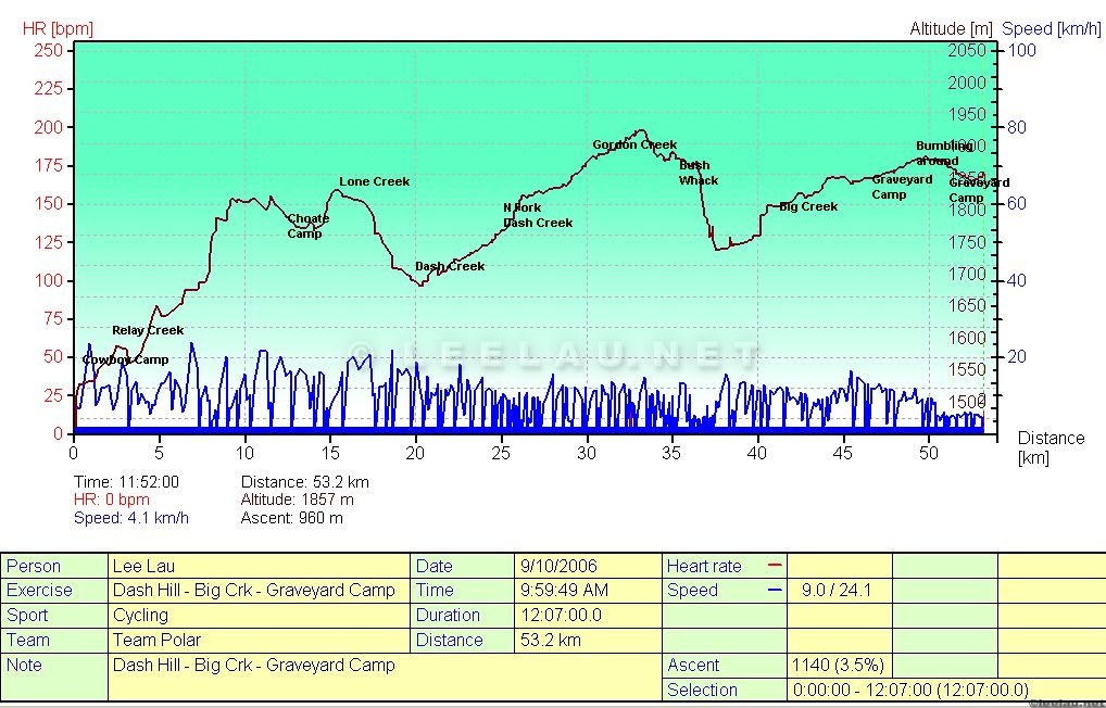
We met with Warren, Casie's husband, the head wrangler, and the owner of SLWA. Tanis was also along as the cook and Pat and Chris were the guides. Our trip started with a drive north of the ranch at Gun Creek to Cowboy Camp on the Relay Creek FSR. The pedalling started after Cowboy Camp at about 10:30am; it took about 2 hours to drive and get started from the ranch to starting point.


I was a bit surprised when it turned out that neither of the guides had ridden Dash Creek before. I had half-jokingly said to Warren when we were planning the routes that he'd have to find some stuff that I'd not ridden. Well, Warren had done well as I had not ridden over half this route so was at the mercy of the guides. An uncomfortable feeling for me as I'm accustomed to being self-reliant on long expedition-style bike trips.
Still all seemed well in the first part of our ride and we were knocking off a lot of distance very quickly.

About 25kms into the ride, navigation got a little tricky. Too my surprise, the guides were both confused with route-finding and neither had map nor compass. Unfortunately we were also off the maps that we had brought but knew the general direction of the camp - west towards Big Creek. Bottom line, the guides were lost, we were lost and eventually resorted to laying a compass bearing and heading west to get to Big Creek. This decision was taken a bit late for my liking, at 5.30pm or so, not leaving us much time to get to the campsite before dusk.


Luckily for us, bushwhacking was easy. The underbrush wasn't thick and that slog went as well as could be expected. By 6.30pm we were looking down on Big Creek. Unfortunately, neither guide knew exactly where the camp was located and we still had less then an hour of daylight to cover about 1.5 hours of riding.


We got to the Graveyard Cabin at about 8pm and broke out the headlights. After another hour of bumbling around trying to find the cabin and letting off a flare and a bear-banger, Warren eventually found us and we made camp. Bless her heart, Tanis had food ready and we collapsed into bed after 55 kms of riding and 12 hours on the bike. Hope that not every day is as eventful as that day.
|| Introduction || Dash Hill || Cluckata Ridge || Elbow Pass || Tyax Creek || Windy Pass |||